2017 CAC Coverage Maps
National Children’s Alliance is dedicated to making Children’s Advocacy Center (CAC) services available to every child in the country. To monitor progress on this mission, NCA creates maps each year for all 50 states that depict CAC locations and select details about the areas they cover.
To find out more about CAC coverage in your state, simply click on the applicable links below. Join us in working toward 100% coverage in every state!
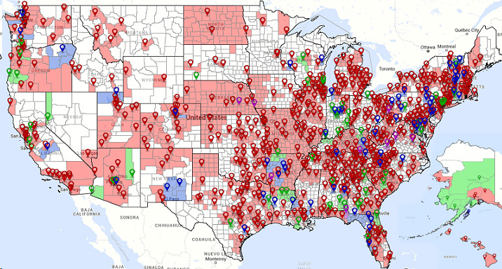
Interactive National Map: Coverage by County
Click the map below to access an interactive national map in our eSpatial software system that includes CAC coverage by county and type. Using this map, you can view CAC locations and coverage areas at a national level and zoom to see more details about the CACs in your local area. CAC locations are approximate—for privacy reasons, the exact address is not displayed. For information about how to interpret these maps, please refer to the description below regarding color-coding and other details on the state-specific maps, as the national maps also follow this formatting.
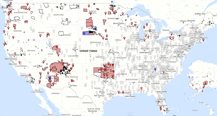
Interactive National Map: Coverage of Tribal Areas
Click the map below to access an interactive national map in our eSpatial software system that includes CAC coverage of federally recognized tribal areas by the tribe’s relationship to its local CAC(s). Using this map, you can view CAC locations and coverage areas at a national level and zoom to see more details about the CACs in your local area. CAC locations are approximate—for privacy reasons, the exact address is not displayed. For information about how to interpret these maps, please refer to the description below regarding color-coding and other details on the state-specific maps, as the national maps also follow this formatting.
CAC Coverage Maps from Past Years
State-by-State CAC Coverage Maps
Two CAC Coverage Maps (or “Gap Maps” as they are often called) were created for each state. Both maps show CAC locations color-coded by their membership status with NCA, as well as outlines of congressional districts, which are helpful when sharing these maps with policy-makers.
The first map for each state (“Coverage Map”) shows the coverage areas of each CAC, primarily by county, color-coded by the NCA membership status of the CAC providing coverage. These areas are considered covered if there is an agreement in place between the CAC and partner agencies in that area, helping to ensure consistent, quality services to the children in that area.
The second map for each state (“Child Population Map”) shows the relative concentration of children under the age of 18 living in each county, according to the 2010 U.S. Census. The darker the green shading, the higher the number of children living in that county. This helps show the potential need for a CAC in that county, helping to either justify to funders and partners the current location of a CAC or demonstrate the need for a new CAC in a county with many children.
The following maps reflect NCA membership status (i.e., accreditation and other categories) as of May 15, 2018. The maps will be updated again in 2019 to reflect any changes since that date.
For more information about the CAC Coverage Maps, please contact Will Laird at .